
This month discover…
The Route of the King's Forest
It's a real lung of Portugal with an extension of 11.000 ha. There existed a previous forest at the same place, however D. Dinis has proceed with its extension and improvement in order to stop the incoming sands, and he became deeply connected to the forest, to the point they start calling him "The Farmer King" and the forest became known as the "King's Pine Forest". However, other person, much less remembered, should be mentioned: Bernardino Barros Gomes. This forester gave order to the woods dividing it into plots by opening firebreaks and paths. He ordered the construction of the first Watch Towers and new houses for the guards, made studies about sowings and resinous materials, he elaborated, in 1882, the first General Chart of Leiria's forest, he created the technical bookkeeping and installed the first meteorology data gathering post.
Between its paths, and firebreaks we discovered threes of public interests such as stone pines, snake pines or huge eucalyptus. A luxuriant vegetation that is worth to visit by foot or car, or even to enjoy a picnic on one of the several parks.
This pine forest was a source of income to the region and to the country. From here leave many of the wood used to built the Portuguese Caravels at the time of the discoveries, populations grown around it due to the extraction of wood, resin, seeds and other activities, forest guards patrolled the area and controlled the materials that got out of the forest.
We went in search of old guard's houses and climbed the watch towers where we saw the hugeness of this forest.
Let yourself go in this green field and come to know this magnificent King's Pine Forest!
How to go around the King's Pine Forest?
The King's Pine Forest is divided into plots, firebreaks and arrifes allowing the visitor an easy orientation.
Plot: the forest is divided into 342 plots, numbered from East to West and from North to South. These are easily identified, since, these numbers are painted directly onto the pine trees, at the beginning and the end of each plot.
Firebreak: firebreaks are paths that cut through the forest horizontally. In Leiria's woods there are 21 firebreaks starting from north to south and from the letter A through the letter T
Arrife: arrifes are also firebreaks but these ones divide the forest vertically. There are 22 arrifes from east to west numbered from 1 to 22.


Guard House of the Beach

GPS coordinates: 39°52'17,139"N 008°57'15,450"W
Guard House of the Plot 1
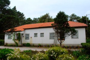 The Guard House of the Plot 1, it is still inhabited and is located at the exit of Vieira de Leiria, on the road connecting to Marinha Grande. The house is very well preserved mantaining its white colour. It must have also some supporting structures such as barns and storehouses.
 GPS coordinates: 39°52'12,445"N 008°56'47,992"W
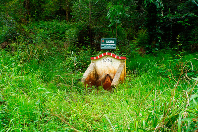
Forest Neighbourhood of Mourão
 The Forest Neighbourhood of Mourão consists of two housing complexes of 4 houses each, is other of those examples where the building came down to us in good condition due to the fact that is still inhabited. Curious is the Guard House of Mourão that sits in a square roundabout. On the other side of the road we can still see the remains of the old shed where the guards stopped the cars to check the materials that the people took from the woods.
  It is still possible to see details in the houses such as the inscription "MN", (acronym for National Forest in Portuguese), that stated their belonging to the state.
 GPS coordinates: 39°51'44,153"N 008°56'12,613"W
House of the 14th Administration
 The house of the 14th administration is located in Vieira de Leiria, near the schools. Consists in the administration building (still in use) of grand looks, two guard houses and some supporting buildings such as a sawmill and storehouses.
 GPS coordinates: 39°51'44,437"N 008°55'57,699"W
Guard House of Cabeça Louçã
 At the start of the firebreak F you will see this beautiful Guard House, with its well, storing, oven house, a barn for the pig and a henhouse. Normally these perks would be given to the guards as a mean of survival. The guards were normally isolated from the populations and in adverse conditions so they had to have this support structures to survive in the middle of the forest.
 GPS coordinates: 39°49'03,966"N 008°53'44,895"W
Guard House of Pilado
 The Guard House of Pilado is located on the plot 94, near a crossroad. The house remains well preserved and inhabited. The village of Pilado is nearby, as well as the soccer field, so you can take the opportunity to get to know the area.
 GPS coordinates: 39°48'50,370"N 008°55'10,336"W
Guard House of Cova do Lobo
 The village of Cova do Lobo gets its name because of the extension of wolfs (lobos in Portuguese) on those parts, once. At the time of the Marquis of Pombal it was cleaned an extention of field with 22 meters wide to prevent fires. That outside strip came to be called Outer Firebreak. Later, in 1790, it was dug a pit with two meters deep and a meter and a half wide, only interrupted by four passage points protected by guards. On one of those points there was the old Guard House of Cova do Lobo. It is one of the oldest in the King's Forest, unfortunately, nowadays it's in a poor state.
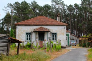 Near it, we find another one, more recent, still inhabited by its former guard.
 GPS coordinates: 39°47'59,890"N 008°55'46,718"W
Guard House of the Sanguinhal
 Between the Guard Houses of Cova do Lobo and Garcia there is the Guard House of Sanguinhal in a poor state. The doors and windows are missing and the abandon signs are more than many. The main door still holds its porch. At the back there were the mean of survival such as henhouses and a small kitchen garden.
GPS coordinates: 39°47'31,831"N 008°56'04,743"W
Guard House of the L.
 At the exit of Garcia, toward the road that connects Marinha Grande to Vieira de Leiria, you will find the Guard House of the L. The House is still inhabited so it still features the main characteristics of the guard houses of the 60 's of the last century.
GPS coordinates: 39°46'28,981"N 008°56'18,553"W
Guard House of the Gaeiras
 A few meters after the housing complex of Pedreanes, is the Guard House of the Gaieiras. The House is in a good state (because it is still inhabited) and you can still see the brick wall that used to be placed in the guard houses.
 GPS coordinates: 39°45'27,058"N 008°56'30,109"W
Guard House of Garcia

GPS coordinates: 39°47'00,402"N 008°56'12,126"W
Guard House of Portela

Coordinates: 39°45'03,291"N 008°56'36,781"W
Neighbourhood of Guarda Nova

GPS coordinates: 39°44'49,549"N 008°56'51,243"W
Building of the Forest Administration

Coordinates: 39°45'04,337"N 008°55'50,297"W
Guard House of Sapinha

GPS coordinates: 39°43'51,862"N 008°58'11,222"W
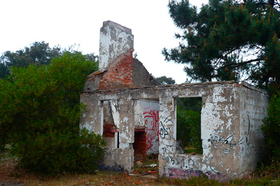
Guard House of Pinhalinho
 Pinhalinho's Guard House is completely in ruins. It's only visible traces of it's existence. Next door is a newer house whose construction was interrupted. Now is also in ruins and vandalized.
Coordinates: 39°43'45,528"N 009°01'22,839"W
Guard House of Rio Tinto
 Located in one of the firebreaks near Tremelgo, the guard house of Rio Tinto is an imposing building that deserved a profound intervention. Currently is closed with bricks, but it is still possible to visit the surrounding area.
GPS coordinates: 39°44’27,947”N 008°57’43,588”W
Guard House of Água Formosa

GPS coordinates: 39°50'34,044"N 008°55'04,620"W
Guard House of Tremelgo
 The guard house of Tremelgo shows obvious signs of the passage of time, however , is located in a beautiful spot to rest a little, with the picnic park, a fountain and a public interest tree. A little further back it is impossible not to stop to see that eucalyptus. The description indicates that it has about 100 years and a height of 48.5 m.
 GPS coordinates: 39°44’09,598”N 008°57’58,451”W
Casa do M
 In fact the house of M is no more. The ruins found in the firebreak M are of an old house support personnel working on fixing and afforestation of dunes. Later, It became a summer home of the volunteer fire department of Marinha Grande.
 GPS coordinates: 39° 46'56.423"N 009°00'44.434"W
Chalet of St. Pedro
 The cottage was built in the 19th century being, possibly, only used as a dormitory for staff who ran the work in that area. Later became the summer residence of the heads of Leiria's forest. It is an iconic building in the village of St. Peter of Moel, with its worked balconies.
GPS coordinates: 39°45'27,253"N 009°01'53,397"W
Guard House of St. Pedro
 The Guard House of St. Peter of Moel served as shelter for the guards who were watching Leiria's forest. Despite the exterior paint need a renovation, the building still retains the splendour of yesteryear. The preservation of this iconic symbol is an asset to the beach of St. Peter of Moel.
GPS coordinates: 39°45'22,779"N 009°01'44,312"W
Guard House of Six
 Hidden in the middle of the Pines, on the road that leads from Marinha Grande to São Pedro de Moel, is the Guard House of Six. This owes its name to the fact that it is at the end of the firebreak nº 6 and unfortunately in a high state of degradation.
 GPS coordinates: 39°44'33,223"N 008°57' 13,995"W
Guard House of the N.
 The Guard House of the N is located near the beginning of the firebreak N (hence the name), following the Pedreanes road to the Gaeiras. Is still inhabited so it is in a good condition, despite being slightly hidden by the vegetation.
GPS coordinates: 39°45’41,076”N 008°56’24,931”W
Forest District of Pedreanes
 Pedreanes is a housing complex that housed, once, the product transformation services that were shipped out of the King's Pine Forest. Dwelling houses for workers, a sawmill, American train station where the cargo was unloaded, warehouses and the guardhouse that controlled entrances and exits. There, we can find the memorial tribute to Bernardino Barros Gomes, erected in 1939.
 GPS coordinates: 39°46'00,183"N 008°56'24,551"W
 The station was built in 1862 (th or 1856 according to Eng. António Arala Pinto) to serve the former American train (or Tin train) being, currently, inserted in the housing complex of Pedreanes. The station still preserves the sign that indicates that it was built by the Duke of Loulé.
 Coordinates: 39º45’59,176”N 008º56’26,587”W
 In the heydays of Leiria's Forest, when numerous people worked in timber extraction, resin and other products, circulated an American convoy through the sands and pine needles. Better known as "Tin train", the train carried both goods and people along the line between 1923 to 1965. At the end it was kept in this shed where you can still see one of the wagons.
 Coordinates: 39º45’58,926”N 008º56’30,509”W' type="text">
 The station was built in 1862 (th or 1956 according to Eng. António Arala Pinto) to serve the former American train (or Tin train) being, currently, inserted in the housing complex of Pedreanes. The station still preserves the sign that indicates that it was built by the Duke of Loulé.
 Coordinates: 39º45’59,176”N 008º56’26,587”W
In the heydays of Leiria's Forest, when numerous people worked in timber extraction, resin and other products, circulated an American convoy through the sands and pine needles. Better known as "Tin train", the train carried both goods and people along the line between 1923 to 1965. At the end it was kept in this shed where you can still see one of the wagons. Coordinates: 39º45’58,926”N 008º56’30,509”W' type="text">
Pedreanes is a housing complex that housed, once, the product transformation services that were shipped out of the King's Pine Forest. Dwelling houses for workers, a sawmill, American train station where the cargo was unloaded, warehouses and the guardhouse that controlled entrances and exits. There, we can find the memorial tribute to Bernardino Barros Gomes, erected in 1939. GPS coordinates: 39°46'00,183"N 008°56'24,551"W
The station was built in 1862 (th or 1956 according to Eng. António Arala Pinto) to serve the former American train (or Tin train) being, currently, inserted in the housing complex of Pedreanes. The station still preserves the sign that indicates that it was built by the Duke of Loulé. Coordinates: 39º45’59,176”N 008º56’26,587”W
In the heydays of Leiria's Forest, when numerous people worked in timber extraction, resin and other products, circulated an American convoy through the sands and pine needles. Better known as "Tin train", the train carried both goods and people along the line between 1923 to 1965. At the end it was kept in this shed where you can still see one of the wagons. Coordinates: 39º45’58,926”N 008º56’30,509”W
Guard House of the Plot 91
 The Guard House of the Plot sits at the exit of the village of Pilado. It's a complex of 2 houses and supporting structures that are still inhabited. It has a well preserved surrounding area (as well as the house itself) near many vine trees.
GPS coordinates: 39°48'43,063"N 008°54'14,699"W

Bridge of Tercenas

GPS coordinates: 39º52’48,703”N 008º57’44,292”W
Lookout Tower of the Hills
 The Lookout Tower of the Hills belonged , once, to the line of lookout tower of the King's Forest. By being outside the edge of the forest, served as protection to both the forest of Leiria as well as the woods of Pedrogão in it's contiguity. The Lookout Tower is located at Mirante's street (that owes its name to the tower itself) and it is private property now. What justifies, until, its brilliant condition.
Coordinates: 39º45’25,440”N 008º55’55,617”W
Fountain of Água Formosa

GPS coordinates: 39°50’39,037”N 008°55’13,953”W
Saibreira's Lagoon
 In the 50, were extracted huge amounts of gravel, in the plot 53, for the construction of new forest roads. After that the site was abandoned. Over the years was accumulating rainwater making it into the lagoon you see today. It's a film that almost looks like a post-apocalyptic scenario perhaps due to submerged pine trees. It's worth the visit.
Coordinates: 39°49'55,124"N 008°54'46,289"W
Stone Pine of the Plot 52
 At the plot 52 you will going to bump into a stone pine tree. And the expression "bump" is well used because the pine tree serves as a roundabout. It is located a few meters from Saibreira's Lagoon and near the Guard House of Pilado.
GPS coordinates: 39°49'48,125"N 008°54'46,813"W
Lookout Tower of Crastinha
 The Lookout Tower of Crastinha provides a stunning view of the surrounding area and coastline. The lookout point served (and still serves) for monitoring the forest against fires. This tower has an adjoining house, already quite degraded, but that does not deprive the local beauty.
GPS coordinates: 39°49'52,995"N 008°58'15,919"W
Samouco's Fountain

GPS coordinates: 39°49'05,510"N 008°59'32,128"W
"Breasts of the Queen" - Breasts Queen
 It's odd, but it's true. Exists in Leiria's Forest two round-shaped dunes known popularly as "Queen's Breasts". José Martins Saraiva in his book "Legends of Leiria's Forest" said that at the time of D. Dinis, when was the planting of pine forest, the men, in view of the difficulty in winning the irregular surface of the steep dunes, were of the opinion that such should be softened but, D. Dinis replied: "- No! With effort we will do the work and, if you look closely, these dunes, put together, have the form of a woman's breasts! We wont take down so sweet forms of nature!". It is clear that after this episode the dunes became known as "The Queen's Breasts".
GPS coordinates: 39°48'33,059"N 008°58'17,845"W
Pine Tree of the Plot 154
 At the plot 154 will find a pine tree that belongs to a set of public interest trees. The pine tree has a height of 28.5 m, a perimeter to 1.3m of 2.56m and a diameter of 21.3m at the canopy.
GPS coordinates: 39°48'30,314"N 008°58'05,133"W
Pine Tree of the Plot 152
 At the plot 152 there is another huge pine tree. This pine tree is distinguished from the rest by its size and by its height.
GPS coordinates: 39°48'12,133"N 008°57'27,062"W
Snake Pine Tree of Pedras Negras
 Living beings have many ways to adapt to the environment into which they are inserted. One of these examples can be found in Pedras Negras. The winds and salinity have prevented the normal growth of pines "forcing them" to crawl through the sand. These pine crawlies, also known as "snake pines" are an impressive surprise of the King's Forest.
GPS coordinates: 39°46'53,618"N 009°01'00,474"W
The Four Pines

Coordinates: 39°46'33,960"N 008°59'30,697"W
The Machine Park

Coordinates: 39°45'48,488"N 008°55'59,69"W
Lookout Tower of Boavista
 The lookout tower was built in Boavista 1885 for replacement of the lookout tower of the building of the resin. This tower, fby being outside the wood it watched, not only the pine forest but it also received and sent information to the other towers through flags (when day) or with lights (at night). The Watch Tower is distinguished by its resemblance to a lighthouse.
GPS coordinates: 39°45'33,708"N 008°55'29,886"W
Mark Pombalino and Resin factory

Coordinates: 39°45'00,626"N 008°56'00,161"W
Pines Trees of Praia Velha
 The stream of Moel flows into the Praia Velha, near São Pedro de Moel. There you will find snake pine trees, but also, others quite low and almost without trunk. This is another phenomenon of the King's Forest, and despite appearances, these are centuries-old pine trees, to which the strength of the winds and salinity did not allow a normal growth.
 GPS coordinates: 39°44'09,598"N 008°57'58,451"W
Lighthouse of Penedo of Saudade

GPS coordinates: 39°45’ 28,249”N 009°01’ 47,237”W
White Well

GPS coordinates: 39°44’51,036”N 008°57’19.519”W
Fountain of the 20

 This fountain, known by the name of the firebreak where it's located, stays on the left bank of the stream of Moel, in the plot 249. The fountain of the firebreak 20 is slightly concealed by vegetation, so it can go unnoticed. Nearby you can enjoy the beauty of the Moel stream and of its waters.
 GPS coordinates: 39°46'22,627"N 009°00'44,922"W
Ponto Novo
 Formerly known as the Ponto da Ladeira Grande, the Ponto Novo has been renovated (as well as the Crastinha point and Facho) by Eng. Mário Amaro Santos Galo in 1936. Is set in a viewpoint that offers an excellent view to the pine forest. In the summer is still used as a lookout post.
GPS coordinates: 39°45'56.362"N 009°00'14.018"W
Giant Eucalyptus
 At the plot 267 you will encounter several large eucalyptus, with almost 70 meters high. It is said that is currently is the set of Europe's tallest trees.
GPS coordinates: 39°45'49,711"N 009°00'54,844"W
The King's Dovecote


GPS coordinates: 39°45'29,980"N 008°59'49,970"W
Astronomical Observatory
 At the plot 284, on the spot popularly known as Alto dos Picotos, is the Astronomical Observatory of the King's Forest. The Observatory was opened in 2000 and held the largest robotic telescope in the country. Consists of a dome with three meters in diameter and a central body where was installed, even, an Automatic computer for tracking of meteors. Next to the building is visible traces of the old Guard House of Queimada. These days it seems to be, unfortunately, abandoned and presents some signs of deterioration, however, still join there some astronomy enthusiasts when occur phenomena of interest.
GPS coordinates: 39°45'07,813"N 009°00'44,295"W
King's Milestone
 This may be the best kept secret of the King's Forest. At the back of Água de Madeiros Hotel exists a firebreak that leads to the "Royal Milestone". Climb all the way up to the ridge overlooking the sea and go around the houses following the firebreak. It is estimated that this could be one of the oldest landmarks in the woods and its a magnificent specimen of history that can be found here.
Lookout Post of Facho
 To get to the Lookout Post of Facho you must follow a road that is not in the best conditions (like many of the roads in the forest). At the top of the hill a fine tower with a den in the top presents itself white against the blue sky. The tower is the forest protection against fires in the summer period.
Coordinates: 39° 42'55,452"N 009°00'02,854"W
Springs of Ponte Nova
 After Ponte Nova you will find a slightly larger fointain than the previous ones and with two side walls. In one of them is engraved, embossed, the images of D. Dinis and Queen Isabel in a intimate framework that brings an additional beauty to this fountain.
 GPS coordinates: 39°46'04,725"N 009°00'21,425"W ''
 This source is at Ribeiro de Moel and a picnic. Idyllic place to rest and to enjoy the small waterfall. Cross the wooden bridge and stroll through the trees. Vai see vale a pena.
 GPS coordinates: 39°46'01,783"N 009°00'14,719"W
Remarkable trees of Tremelgo


 You may, still, find the traces of the highest pine tree in the Iberian Peninsula. It was a giant of over 40 meters and 4,50 m of perimeter, that unfortunately could not withstand the storm of January 2013. Curiously, it was thought that had more than 200 years old, however, with the possibility to counting its rings, after the fall, it was realised that it hasn't reached 100 years... we lost a true phenomena!
 GPS coordinates: 39°44'34,636"N 008°57'44,837"W
Fonte de S. Pedro
 The source of San Pedro de Moel is part of a vast network of sources there through the woods. It was built by management Matas at the request of area residents. The water had been piped directly from the spring in the valley near this location. Water flowed continuously but, in years 80 's of the last century, It was replaced by tap water for health safety reasons.
Coordinates: 39° 45'21,182"N 009°01'53,648"W
Statue of King D. Dinis and Queen Isabel
 Dinis is closely connected to Leiria's Forest. It's because of him that this forest is best known as the King's Forest. I should already exist vegetation on this place before the monarch's intervention. The planting of the pine forest was, after all, ordered by D. Afonso III, in the 13th century. D. Dinis increased it through the sowing of pine trees having, also, established the first regional planning regulations and management of the forest. The monument to the King. Dinis and Queen Isabel was created by the sculptor Numídico Bessone and offered to the city of Marinha Grande by the Minister of Public Works in 1972. Continue to be deposited flowers by the statue because of the great devotion of the people to the holy queen.
Coordinates: 39°45'24,459"N 009°01'40,797"W
Fountain and Eucalyptus of Tremelgo
 This fountain was one of the most popular of Leiria's Forest, due to the fame and the quality of its water and its properties. Water sellers and general population made queues to fill their containers.
  A little further back it is impossible not to stop to see that eucalyptus. The description indicates that it has about 100 years and a height of 48.5 m.
 GPS coordinates:
Source: 39°44’09,598”N 008°57’58,451”W
Eucalipto 39°44'12,700"N 008°58'01,664"W
Eucalyptus of Ponte Nova
 Near Ponte Nova, there are large eucalyptus trees considered of public interest. The eucalyptus is a tree originally from Australia and which is in abundance in Leiria's Forest. On the other side of the river, a picnic Park invites you to a over extended rest.
 Coordinates: 39°46'01,783"N 009°00'14,719"W
Cypress of the Swamps
 Near the Guard House of Garcia's there is a picnic park that distinguishes itself from others because of several trees of public interest, the Cypress of the Swamps. It is a lovely place, where you can hear the water running. The trees, of rare characteristics in Portugal, originate from the south-eastern United States ' wetlands and from the Gulf of Mexico. Careful not to stumble in their roots that may be something tricky. We can also find these roots in Formosa and Tremelgo.
 Coordinates: 39°47’00,402”N 008°56’12,126”W
Samouco
 Samouco is the common name for Beech of the Islands (Myrica faia Aiton.) and is one of the phenomena of the forest, in fact, the Samouco is a shrub, but here thanks to the richness of the soil and water, became, without anyone knowing very well how, a gigantic tree. It has a height of 18 m and was classified as public interest in 1997.
GPS coordinates: 39°49’05,510”N 008°59’32,128”W
Fountain of the plot 261
 Along the path that leads to Ponte Nova are various fountains. These keep the original traits and the inscription "MN", (acronym for National Forest in Portuguese). The water is not controlled so you should not drink it.
 GPS coordinates: 39°45'39,264"N 008°59'21,133"W 39°45'38,552"N 008°59'16,375"W
Primary Dune
 To proceed to the afforestation of the track along the coastline was necessary to create an obstacle that stop the sanding of this ribbon, the primary dune. The dune was achieved through the placement of wooden slats, slightly set appart, of which we can still see some remains, that builds up the sand. The primary dune is quite extensive, coming up near Aveiro. It's a brilliant work of forest engeneering.
GPS coordinates: 39°51'06,255"N 008°59'02,996"W
Valley of the Fireflies and Fountain of Felicia
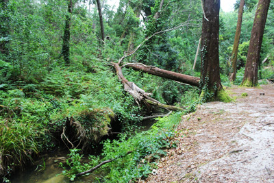 At the plot 259 go down a hill where previously there would be some wooden stairs. At the bottom you will encounter an idyllic picnic park, near the stream, called Valley of the Fireflies, maybe because it had been there many fireflies or for a connection with the lanterns of the tents of people who stayed overnight. After the storm of 2013 many trees came down and were left there purposely. Removing them would damage the space and it even gives a fantastic atmosphere to the place. We hope that, when you visit, you contribute to the preservation of the place.
 There you will find even the fountain of Felicia whose legend says that the Prince D. Afonso, son of D. Dinis and D. Isabel, after drinking the water, found it light and fresh and asked his mother what the was the springs name. The Queen, remembering, maybe, of some moment of happiness, replied "it's the fountain of Happyness, my Prince. "
GPS coordinates: 39°45'25,515"N 008°59'06,923"W
Fountain of Amieiros
 Before reaching the roundabout of the Ponte Nova you will find a picnic Park next to the stream of Moel. On the other side of the road, a high and right pine tree hides a narrow path that leads, among ferns and the noise of the water, to a small wooden bridge. Soon after you are going to see the Fountain of the Amieiros.
GPS coordinates: 39°45'34,494"N 008°59'27,071"W
Sand Dune
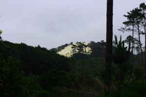 The King's Pine Forest has the 2nd highest sand dune in Europe, is located at the plot 139 and it's worth a climb to the top to see all the surrounding panoramic. This Dune was of fundamental importance in the economy of the region in the 20th century, because it was from there that were extracted the sands for the construction and the glass industry.
GPS coordinates: 39°48' 47,938"N 008°58' 22,057"W
Pine Grafted
 There are copies of the Leiria pine forest in an absolutely stunning trees. Many of them are the work of nature, but this time we find modified copies Man. These trees were grafted on top of other eventually grow very straight towards the sky, however, They seem to have no shell.
Coordinates: 39° 47'21,514"N 008°57'51,596"W
Sources:
Our tribute to the blog Pinhal do Rei, an authentic encyclopedia about this forest, on wich we have inspired shamesly: http://opinhaldorei.blogspot.pt
Weekly Newspaper Região de Leiria – Extra edition King's Forest, 9 of April, 2015: here